Introduction: How Navigation Tools Elevate Every Journey
Navigation tools have come a long way since the days of paper atlases and compass needles. Today’s explorers can tap into a vibrant mix of digital apps, GPS devices, and user-generated maps to reach their destinations faster, safer, and with fewer headaches. Whether you’re mapping out an epic road trip, hiking a remote trail, or just roaming around a city, the right navigation tools can mean the difference between a seamless experience and a trip riddled with wrong turns. In this comprehensive guide, we’ll explore the essentials of modern navigation, show you how to pick the best devices and apps, and share tips for mastering them in a variety of travel scenarios.
Why Navigation Tools Matter More Than Ever
Reliable navigation isn’t only about saving time—it’s also about discovering hidden places, handling unexpected detours, and reducing stress. With modern travelers craving flexibility, the right tools can help you shift your route instantly, tailor your pace to local conditions, or spot scenic stops that conventional directions might skip. Even in busy urban centers, advanced navigation apps can guide you through public transit, walking paths, and cycling lanes with real-time updates.
Key Benefits
1. Time Efficiency: Quickly choose the fastest or most scenic route to your goal.
2. Safety and Confidence: Knowing exactly where you are eliminates needless worry, especially at night or in unfamiliar areas.
3. Discovery: Many apps highlight points of interest, hidden trails, or lesser-known detours you might otherwise miss.
4. Adaptability: In case of traffic jams, closures, or weather changes, you can recalculate directions on the fly.
---
Core Categories of Navigation Tools
From handheld compasses to cutting-edge augmented reality apps, navigation options cater to different preferences and trip types. Understanding these categories helps you build the perfect toolkit for your journey.
1. Traditional Paper Maps and Atlases
Despite the digital revolution, paper maps remain a staple—especially in regions with limited connectivity or for travelers who enjoy hands-on planning. They offer a bird’s-eye perspective, letting you visualize a broader area at once.
Advantages of Paper Maps
- No Battery Required: Ideal for extended hikes or rural road trips where devices may fail.
- Immediate Overview: Great for seeing how distant landmarks relate to each other.
- Tactile Appeal: Many enjoy marking routes, making notes, and folding it into a pocket.
2. Smartphone Navigation Apps
Apps like Google Maps, Apple Maps, and Waze have become household names. They blend GPS location tracking with real-time data on traffic, public transit, and user reviews, all in a user-friendly interface.
Powerful Features
- Voice Guidance: Stay focused on the road with spoken turn-by-turn directions.
- Offline Access: Download maps for areas with poor reception, letting you navigate without data service.
- Integrated Search: Find nearby restaurants, gas stations, or attractions with instant results and user ratings.
3. Dedicated GPS Devices
Car-mounted GPS units from brands like Garmin or TomTom remain popular for drivers seeking reliable navigation that doesn’t depend on phone data. Rugged handheld GPS units cater to hikers, climbers, and explorers who venture off-grid.
Why Dedicated GPS Still Thrives
- Strong Signals: These devices use high-sensitivity receivers that maintain a GPS lock even in forests or canyons.
- Optimized for Driving or Hiking: Car models have large screens and auto-lane suggestions, while handhelds show topographic lines and track logs.
- No Cellular Requirement: They work purely off satellite connections, making them perfect for remote treks.
4. Wearable and AR Navigation
Smartwatches, heads-up displays, and augmented reality apps represent the cutting edge of navigation. They let you see arrows on the sidewalk or on your phone’s camera view, or simply glance at your wrist for the next turn.
Features to Note
- Discrete Directions: Vibrations or subtle on-screen prompts guide you without brandishing a phone.
- Fitness Integration: Many smartwatches track steps, heart rate, and routes for health goals.
- Battery Concerns: AR and constant GPS usage drain power quickly, so plan with a backup battery or charger.
---
Choosing the Right Navigation Tool for Your Travel Style
Pinpointing the best navigation solution depends on whether you’re primarily driving, hiking, using public transport, or simply strolling around. Below are scenarios with recommended options.
1. Urban Explorations
City tourists often juggle subways, buses, and walking tours. A smartphone app with real-time public transit details is invaluable, but it’s wise to have a small paper map for an overview of neighborhoods.
City Strategy
- Real-Time Crowd Data: Some apps show station or route congestion, letting you choose less busy paths.
- Sleek Wearables: Checking your watch for directions beats exposing your phone to potential theft in crowded areas.
- Offline Backup: In case phone service drops, a foldable map or screenshot can save the day.
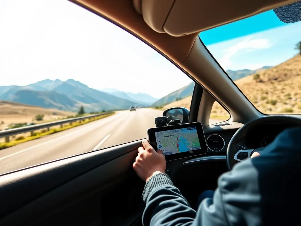
2. Road Trips
For scenic drives or multi-state journeys, a dedicated car GPS or robust smartphone app with offline capabilities works best. Combine it with a road atlas for broader context and alternative route ideas.
Road Trip Essentials
- Voice-Enabled Alerts: Keep your eyes on the road. Lane guidance can be a lifesaver at complex interchanges.
- Traffic Updates: Real-time data can help you dodge highway backups or construction areas.
- Local Speed Limits: Many GPS devices or apps warn you if you exceed posted limits.
3. Hiking and Outdoor Adventures
Venturing into mountain trails, deserts, or remote forests necessitates specialized tools. Handheld GPS units or smartphone hiking apps with offline topographic maps are vital. Always carry a physical backup map and compass, in case electronics fail.
Outdoor Focus
- Waypoint Marking: Plot your campsite, scenic overlooks, or water sources for reference.
- Elevation Profiles: Evaluate difficulty by checking the slope of the terrain.
- Weather Integration: Some devices overlay live weather forecasts or hazard warnings.
4. Backpacking Across Countries
Long-term travelers jumping borders rely on offline phone apps, pre-downloaded maps, or multiple sim cards. In less developed areas, paper maps or multi-country road atlases deliver broader coverage than specialized city guides.
Backpacker Best Practices
- Adaptable Layers: Switch from city-specific maps in capitals to large-scale country overviews during bus rides.
- Limited Battery or Data: Plan for minimal phone usage. Paper backups or dedicated GPS can keep you on track.
- Coordinate with Locals: Mark your map with suggestions from hostel staff or fellow travelers.
---
Essential Features to Maximize Your Navigation
Any decent navigation tool should let you plan routes, but true excellence comes with specific advanced capabilities that make each mile smoother and more fun.
1. Offline Map Downloads
Even if you rely on a smartphone, offline downloads can rescue you when networks drop. Google Maps, Maps.me, and other apps let you store entire areas offline, complete with POI data and basic routing.
Offline Best Practices
- Pre-Trip Downloads: Use Wi-Fi to save large map files for the entire region.
- Regularly Update: Road conditions change, so re-download every month if you’ll be in the same place a while.
- Limited Space: Full countries can be huge; if storage is tight, focus on just the cities or routes you’ll visit.
2. Real-Time Traffic and Hazard Alerts
Driving apps can show sudden traffic build-ups, accidents, or even police speed traps (Waze users share these). Such data lets you reroute in seconds, skipping out on potential hours in jammed roads.
Handling Traffic Intelligence
- Time-of-Day Planning: Some apps forecast peak congestion intervals, letting you adjust departure to calmer slots.
- Event Overlaps: Big stadium gatherings or city festivals might block roads. Real-time alerts help you dodge gridlock.
- Navigate to an Alternate: If a recommended route becomes clogged, second or third route suggestions pop up automatically.
3. Step-by-Step Walking or Transit Guidance
Pedestrian or transit-focused instructions are extremely handy in large cities. They detail which exit to take from a station, which bus line to pick, or how many stops to ride before transferring.
Public Transport Gains
- Schedule Sync: Apps like Citymapper show next bus or train departure times in near-real-time.
- Detailed Transfers: If you must switch lines, the app can specify the station area or platform location.
- Fare Info: Know your ticket costs upfront, or whether multi-day passes are more economical.
4. Personalized Route Saving and Sharing
Many advanced apps let you create custom routes or pin favorite spots, which you can share with travel buddies. This fosters collaboration if you’re traveling in a group or prefer crowdsourced insights.
Benefits of Custom Routes
- Group Coordination: Everyone sees the same route updates or pinned POIs.
- Thematic Focus: Plot a gastronomic tour or historical loop, then fine-tune it day by day.
- Cross-Device Sync: Start planning on a laptop, then open the route on your phone while on the street.
---
Common Pitfalls and How to Overcome Them
Even the best navigation setups can fail if travelers aren’t vigilant. Here are typical snags and how to preempt them.
1. Overreliance on a Single Source
Any app or GPS can have errors—like an outdated POI or inaccurate road closure. Cross-verify major details with local advice or official websites, especially if the route is time-sensitive.
2. Ignoring Battery Limits and Spares
Continuous GPS usage drains power rapidly. For big day excursions, bring a power bank, keep your phone on airplane mode if possible, or rely on a secondary device like a dedicated GPS unit.
3. Confusing Shortest Distance with Fastest Time
A route might appear short on a map but could wind through slow mountain roads or congested city centers. Rely on estimated times, not just distance, and factor in local conditions.
4. Underestimating Terrain or Weather Impact
This especially applies to hiking. A path that looks short might be extremely steep or prone to flash floods. Check topographic overlays or local weather advisories if you venture off-grid.
---
Practical Tips for Seamless Navigation
Regardless of your chosen method or device, adopting certain habits ensures consistent, hassle-free navigation throughout your trip.
1. Calibrate Your Compass or Sensors
Many phones have built-in compasses that need occasional recalibration for accuracy. Car GPS units might need initial setup for vehicle size or preferences (like avoiding toll roads).
2. Use Landmarks as Reference Points
In chaotic city layouts, apps sometimes lag or misplace your icon. Knowing you’re near a notable building or monument can orient you faster than waiting for the device to catch up.
3. Embrace Pedestrian-Mode Features
Driving directions aren’t always ideal when you’re on foot, especially in pedestrian malls or footpaths. Toggle “walking” or “biking” modes for precise instructions tailored to your movement speed.
4. Keep a Paper Backup Map in Unfamiliar Terrain
Even if you’re a digital devotee, a folded city map or national atlas can rescue your itinerary if technology falters. Mark your last known location or planned route to remain surefooted.
---
Future Directions: Where Navigation Tools Are Heading
Rapid innovation means tomorrow’s travelers might rely on even smarter, more integrated systems. Expect new levels of convenience, personalization, and immersion in the near future.
1. Augmented Reality (AR) Wayfinding
Some apps already overlay directions onto live camera feeds, labeling streets or highlighting store entrances. Future expansions could incorporate real-time crowd data or highlight interesting facts as you walk.
2. AI-Driven Custom Routes
Picture an app that learns your travel preferences—quiet roads, scenic views, or direct highways—and auto-adjusts each recommended route. Machine learning might compile traveler data and local feedback for hyper-personal suggestions.
3. Expanded Offline Intelligence
Offline maps already exist, but expect deeper offline features: local user reviews, relevant photos, or updated events even without active data, thanks to incremental background downloads or advanced caching.
4. Voice-First Navigation and Chatbots
Rather than typing or scrolling, advanced voice assistants could let you have a conversation about your route—“Find me a scenic waterfall within 2 hours” or “Reroute to avoid that upcoming parade downtown.”
---
Conclusion: Charting Your Course with Confidence
Navigation tools, in all their varied forms, aren’t just about pinpointing your location—they’re about shaping richer travel experiences. By blending offline backups with real-time apps, leveraging specialized features, and staying mindful of common pitfalls, you can transform even the trickiest routes into memorable, stress-free journeys. Whether you’re trekking rugged trails, weaving through urban crowds, or crossing multiple borders in one trip, the right navigation setup is your ticket to spontaneity and discovery.
Embrace the synergy of old-school paper reliability and cutting-edge digital intelligence. Together, they cater to the broad spectrum of travel scenarios, from everyday commutes in strange cities to epic expeditions in remote landscapes. And as technology advances, so does our capacity to roam with greater freedom and fewer wrong turns. Let this guide serve as your compass—pointing toward the perfect blend of convenience, safety, and adventure whenever you set out to explore.
Final Tips
- Test Drives: Before a major trip, try your chosen app or GPS on minor outings to get familiar with settings.
- Multiple Layers: Use your main tool for directions and a secondary reference (like a specialized hiking app) for specific terrain data.
- Stay Updated: Frequent map or app updates ensure you’re not following outdated roads or closed trails.
- Adapt and Improvise: If unexpected roadworks or weather hamper your original plan, trust your nav tools to reroute safely—and enjoy the detour as part of the journey.
Leave a Comment